Designed by Nigel G Wilcox
Introduction To Detectorists - Reference

Member NCMD
Powered By Sispro1

How to plot a National Grid Reference.
Plotting a grid reference of finds is essential to maintaining the integrity of their context (in other words to understand what type of archaeological site they have come from). Without a grid reference, archaeological finds are meaningless; they don't relate to the landscape or what is already known about the archaeology of an area.
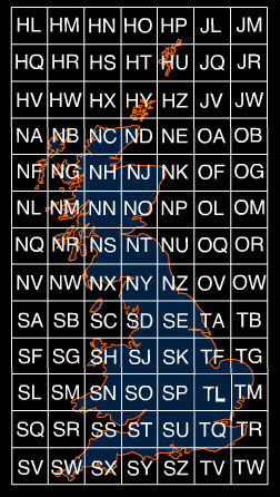
Great Britain has been laid out on a grid system by the Ordnance Survey, and these squares measure 100 km by 100 km. To make it easy to identify the squares, they have each been assigned a two letter code. This forms the prefix of the National Grid Reference.
Plotting a grid reference of finds is essential to maintaining the integrity of their context (in other words to understand what type of archaeological site they have come from). Without a grid reference, archaeological finds are meaningless; they don't relate to the landscape or what is already known about the archaeology of an area.
Great Britain has been laid out on a grid system by the Ordnance Survey, and these squares measure 100 km by 100 km. To make it easy to identify the squares, they have each been assigned a two letter code. This forms the prefix of the National Grid Reference.
Figure 1: The Grid layout of Great Britain.
These grid squares can then be broken down into more squares, of 10 km by 10 km. This is shown for grid square SP below.
These grid squares can then be broken down into more squares, of 10 km by 10 km. This is shown for grid square SP below.
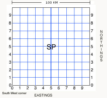
Figure 2: The basic layout of grid square SP.
The basic premise for this is that the square is broken down into 10 segments by 10 segments (or 100 squares), numbered from 09 from the southwest
corner horizontally and vertically.
The basic premise for this is that the square is broken down into 10 segments by 10 segments (or 100 squares), numbered from 09 from the southwest
corner horizontally and vertically.
1. The reading from the bottom left hand corner of the square to the bottom-right forms the
EASTING.
2. The reading from the bottom-left hand corner of the square to the top left-hand corner forms the
NORTHING.
3. Thus National Grid Reference SP85 is the square labelled SP85 below:
EASTING.
2. The reading from the bottom-left hand corner of the square to the top left-hand corner forms the
NORTHING.
3. Thus National Grid Reference SP85 is the square labelled SP85 below:

Figure 3: Grid square SP with square SP85 labelled.
Each of these smaller squares is numbered from 0 to 9 from the south-west corner, both horizontally (eastwards) and vertically (northwards). The easting (left to right) is stated first, then the northing (up and down). To remember this, think about going through your front door: along the corridorand up the stairs.
Each of these smaller squares is numbered from 0 to 9 from the south-west corner, both horizontally (eastwards) and vertically (northwards). The easting (left to right) is stated first, then the northing (up and down). To remember this, think about going through your front door: along the corridorand up the stairs.
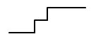
Along the corridor And up the stairs. Figure 4: Schematic for reading the reference.
Therefore, to reach SP85, one goes across to square 8 on the bottom row, and up to square 5 on the vertical row. This produces NGR SP85.This produces a grid reference to a precision of 10 km. This can be narrowed down, however, to a 4-figure grid reference The next few images show how a 1km grid precision can be produced.
The blue square represents a geographical location. By using a straight line rule, you will be able to subdivide the square again into another 100 squares. Therefore any grid reference you will quote will follow the lines of SP ( Grid Square )X (Easting) Y (Northing) . Hence a grid reference for 1km would be, for example SP 88 57.
The blue square represents a geographical location. By using a straight line rule, you will be able to subdivide the square again into another 100 squares. Therefore any grid reference you will quote will follow the lines of SP ( Grid Square )X (Easting) Y (Northing) . Hence a grid reference for 1km would be, for example SP 88 57.
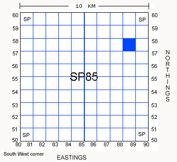
Figure 5: Theoretical point in grid square.
By dropping in a vertical line across the grid square, locate the bottom left hand corner of the blue square, you will be able to produce the EASTING.
By dropping in a vertical line across the grid square, locate the bottom left hand corner of the blue square, you will be able to produce the EASTING.
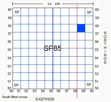
Figure 6: Easting laid down from the point.
This produces the NGR of SP 88XX. All one has to do now, is obtain the value of X . Once this has been obtained, you will be able to produce a 4 figure NGR.
Thus, you now need to drop in a horizontal line, along the base of the blue square. This will then give you the figure of your Northing . The diagram below demonstrates the two lines superimposed to develop your Easting and Northing.
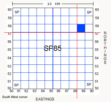
Figure 7: Northing and easting bisection point.
The horizontal line bisects the line at the spatial point 57. Therefore, the full 4 figure grid reference for the maroon dot is equal to SP 88 57. National Grid Reference to 6 Figures.
In a real life situation, one obviously needs a greater degree of precision. The next diagram shows how to get a grid reference to 6 figures, giving a precison of 100 x 100 metres.
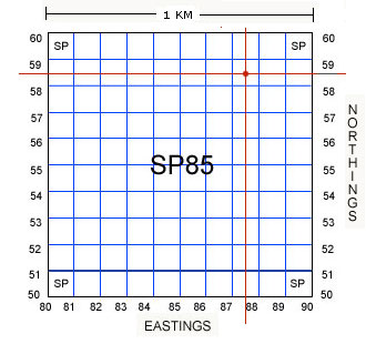
Figure 8: 6 figure grid reference laid out.
Following the same methodology as demonstrated in the examples above:
The prefix for the NGR is: SP
The easting for the NGR is: 875
The northing for the NGR is: 585
Thus the NGR in full is: SP875585
Following the same methodology as demonstrated in the examples above:
The prefix for the NGR is: SP
The easting for the NGR is: 875
The northing for the NGR is: 585
Thus the NGR in full is: SP875585
If you want to increase the precision of your grid references, you need to repeat the above within a yet smaller grid square.
The levels of precision are shown below:
0 figure [SP] = 100 kilometre square
2 figure [SP85] = 10 kilometre square
4 figure [SP8252] = 1 kilometre square
6 figure [SP825525] = 100 metre square
8 figure [SP82555255] = 10 metre square
10 figure [SP8255552555] = 1 metre square
12 figure [SP825555525555] = 10 centimetre square
If you take your finds for recording with a Finds Liaison Officer, grid references taken to a precision of 8 - 10 figures are the most useful. It is also beneficial to view maps together and confirm your grid references.
Copyright All Rights Reserved by Nigel G Wilcox E-Mail: ngwilcox100@gmail.com
Complimentary Topics:
The Paragon Of Metal Detecting
& Archaeology
& Archaeology
Reference Menu
Pages


Looking After Finds>>>